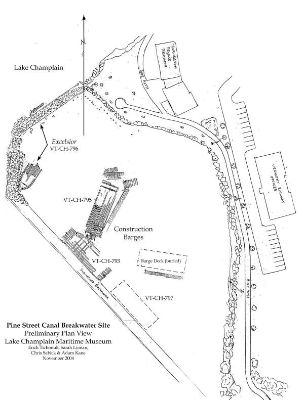
The Pine Street Canal Breakwater site contains the remains of four vessels: three mid-twentieth century construction barges (VT-CH-793, VT-CH-795, and VT-CH-797) and the mid-nineteenth century lake schooner Excelsior (VT-CH-796). The sites were initially located during a 1991 Phase I Archaeological Survey for a Proposed AT&T Fiber Optic Cable Line from Burlington, Vermont to Keesville, New York.
The shipwrecks documented within the Pine Street Barge Canal Breakwater site lie outside of the entrance to the Pine Street Canal in Burlington, Vermont. This small barge canal was excavated in the 1860s to facilitate loading and unloading of canal boats along inland Pine Street and the Burlington Waterfront. Burlington was one of the largest lumber ports in the nation at the time. The southern leg of the Barge Canal Breakwater was built in 1868, while the northern leg was finished two years later in 1870. The northern breakwater and another smaller breakwater extending from Roundhouse Point to the north effectively created a small basin in the area north of the Pine Street Canal breakwaters. A gap between the breakwater allowed lake vessels access to this basin, however in 1893 the opening was enclosed with another breakwater.

Plan view of the Pine Street Canal Breakwater site (by Erick Tichonuk, Sarah Lyman, Chris Sabick, and Adam Kane, LCMM Collection)
The basin remained sealed from lake traffic until 1960 or 1961, when researchers believe that the U.S. Army Corps of Engineers removed a portion of the breakwater to allow barges to moor inside the basin. The mooring area was needed because of repair work associated with the 1958 collapse of a portion of the concrete superstructure of the main Burlington Harbor breakwater. The U.S. Army Corps of Engineers completed repairs on the breakwater in 1961 for which several barges contracted through Turner and Breivogel, Inc. from Falmouth, Massachusetts were used. According to Captain Merritt Carpenter, these barges were brought to the lake from the Hudson River and were moored inside the recently opened up basin. After completion of the repair they were abandoned in this same location. The three barges documented by LCMM archaeologists during June and July of 2004 are believed to be those same vessels.
Construction Barges
The survey area within Pine Street Canal Breakwater site is very shallow, with depths not exceeding 10ft (3m). As such, the three wooden construction barges located at this site have been severely affected by ice and storms. The barges now present a jumbled debris field of disarticulated sides, ends, decks, bottoms of hulls and miscellaneous deck hardware.
Through the analysis of these pieces, LCMM researchers were able to distinguish three barge bottoms, five sides and one deck. All three vessels are similar in construction, and were likely built at the same boatyard. The barges are all flat-bottomed with vertical sides and raked ends. The bottoms were constructed of transversely oriented bottom planking overlain by longitudinal stringers and transverse riders. The raked ends of the barges were all disarticulated from the bottoms; however they were formally attached by large triangular chocks joining the framing elements inside the hull. The sides were built of vertically oriented from futtocks. The bases of the futtocks were tenoned into a mortise on the chinelog. The sides did not appear to be edge fastened. Depth of holds, inferred from the scattered sides, varied from 6ft 5in (1.98m) to 8ft 8in (2.68m).
Construction Barge 1 (VT-CH-795)
VT-CH-795 is 87ft (26.5m) long and 32ft (9.7m) in beam. This is the length on keel rather than the length on deck. It is oriented lengthwise approximately 20 degrees from north. The sides are disarticulated and lie to the north and east of the bottom. Both ends are also extant, although they have detached from the bottom of the hull.
Construction Barge 2 (VT-CH-793)
Construction Barge 2 is largely incomplete, but a measurement taken from the chine log was 73ft (22.2m). It lies alongside the southern portion of the submerged breakwater. Some riders and longitudinal stringers are still intact, though the majority of the bottom planking is beneath the sand. The two ends are present, collapsed and flat on the bottom. One side may be present, lying across the northeastern portion of the wreck, and possibly underneath VT-CH-795 to its north.
Construction Barge 3 (VT-CH-797)
The remains of Construction Barge 3 lie parallel to the breakwater, closer to shore than VT-CH-793. Only a few timbers were apparent protruding from the sand, however its construction seemed consistent with the other barges. No measurements were recorded on this vessel.
Information Sources:
Adam I. Kane, A. Peter Barranco, Joanne M. DellaSalla, Sarah E. Lyman and Christopher R. Sabick, Lake Champlain Underwater Cultural Resources Survey, Volume VIII: 2003 Results and Volume IX: 2004 Results. Lake Champlain Maritime Museum, 2007.
Douglas Frink, Charity Baker and Art Cohn, AT&T Fiber Optic Cable Burlington, Vermont to Keelsville, New York Phase 1 Archaeological Study, Essex Junction, VT: Frink and Baker Archaeology Consulting Team, Inc., 1991.
Andrew Lydecker and Anne Cousins, Recording the Burlington Breakwater in Lake Champlain, City of Burlington, Chittenden County, Vermont in Connection with the Proposed Structural Repair Activities and Section 110 Responsibilities, Memphis, TN: Panamerican Consultants, 2002.
